
NWS Huntsville Weather Briefing for Hurricane Irma Potential Impacts
NWS Huntsville Weather Briefing for Hurricane Irma Potential Impacts
|
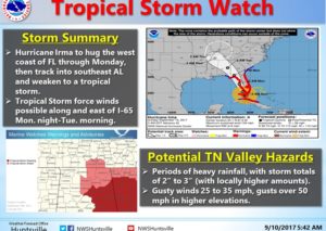
Overview Hurricane Irma is impacting southern Florida this morning. The current forecast track has it taking a turn to the northwest and northward off the coast of Florida on Sunday and Monday. As it does so, it is expected to weaken before arriving over GA/AL by Monday night into Tuesday. As it approaches the TN Valley, it is currently forecast to be a tropical storm. As a result, a tropical storm watch has been issued for portions of northeast, north central Alabama and southern middle Tennessee. |
Warnings/Watches/Advisories:
- Tropical Storm Watch mainly for impacts on Monday night into Tuesday over northeast Alabama, north central Alabama, and southern middle Tennessee.
Impact 1: (Winds)
- Surface winds are expected to increase out of the northwest around 25 to 35 MPH with gusts of 50-55 MPH possible on Monday night through Tuesday.
Impact 2: (Heavy Rainfall)
- Total rainfall amounts are expected to range between 2 to 3 inches from Monday night into Wednesday.
Graphics: see attached graphic
Additional Information: Refer to the National Hurricane Center for the latest advisories. The next update is scheduled by 9AM on Monday morning, unless conditions warrant.
-Stephen Latimer and Andy Kula
—
National Weather Service